Monday, December 17, 2012

SOIL BULK DENSITY & SOIL EROSION


Density

  • Density is the mass, or the amount of material, that a given volume of a substance contains. The  density of fumed silica is 2.2 grams per cubic centimeter while of marble calcium carbonate  the bulk density is 2.72 g/cm3.  Fine-grained clayey–calcareous silicite may have other values.

What is Bulk density?


Bulk density is defined as the weight per unit volume of material.Texture  and organic matter are major modifiers of bulk density.This properties  affect water infilteration rate, movement and water retention in soils which inturn affect water soil erosion.


When is the particle density equal to the bulk density?

This would be true of a perfectly uniform, homogenous material.

Normally  soil are not uniform as result of many soil management practices on properties or different vegetation and slope besides mineral content,pores,organic matter distribution. For example calcareous soils and silica sand (2.2)has different density.Based on index properties measurements made on board the JOIDES Resolution, we(Franck C. Bassinot,2 Janice C. Marsters,3 Larry A. Mayer,4 and Roy H. Wilkens3) studied porosity changes with depth in the fairly homogeneous deep-sea calcareous sediments cored during Ocean Drilling Program Leg 130 on the Ontong Java Plateau.Thus porosity will be reflected in bulk density as well.


Study USLE and Influence oF Calcarious Soils

Soil erodibility defines the resistance of soil to detachment by rainfall impact and/or surface flow force. In the Universal Soil Loss Equation (USLE), the soil erodibility (K) is estimated using the texture, organic matter content, permeability and structure of a soil
The USLE was originally developed for non-calcareous soils in the USA. However, in calcareous soils, calcium is an important factor affecting soil structure and hence may influence soil erodibility. The application of the USLE to calcareous soils therefore requires a reassessment of K. The present study evaluates K and identifies factors affecting K for calcareous soils in Hashtrood City, northwestern Iran. The soils contain 13% lime and 1% organic matter, and are mainly utilized for wheat dry farming. A square agriculture area of 900 km2 was selected and then divided into 36 grids of 5 × 5 km. The erosion unit plots at three replicates with 1.2 m spacing were installed in each grid. K was measured based on soil loss and the rainfall erosivity index from March 2005 to March 2006. The rate of soil loss resulting from 23 natural rainfall events during the study period was measured at the unit plot scale. Various soil properties including the contents of sand, silt, silt + very fine sand, clay, gravel, organic matter, lime, and potassium as well as aggregate stability and permeability were measured in the vicinity of each plot. The results show that K significantly correlates with the contents of sand, silt, silt + very fine sand, organic matter, and lime as well as water-aggregate stability and permeability. The application of principal component analysis (PCA) also indicates that the contents of clay and lime as well as permeability strongly control K. The contents of clay and lime, which have not been well considered in USLE studies, significantly decrease K due to their strong effects on aggregate stability and water infiltration into soil. K can be estimated using a linear regression equation based on the contents of sand, clay and lime.

The influence of many soil manegement practices

The influence of many soil manegement practices on properties that affect water movement and water retention in soils. Because texture texture and organic matter are major modifiers of bulk density,their effect needs to further quantified as to evaluate the influence on erosion


A=RKLSCP
A    =    average annual soil loss in the project or farm area. 
                        R    =    rainfall erosivity index
                        K    =    soil erodibility factor
                        L    =    topographic factor, L for slope length
                          =    topographic factor, S for percent slope
                        C    =    a cropping-management factor
                          =    conservation practice factor


Making Terrace is to reduce slopen length L 


At Mid Slope S is small but without cover C factor is high.This generate splash erosion and run off

Increasing Run off volume gain momentum (kinetic enenergy) as run of  flow down  slope

Steeper slope generate greater kinetetic energy of runoff


View From Tikam Batu
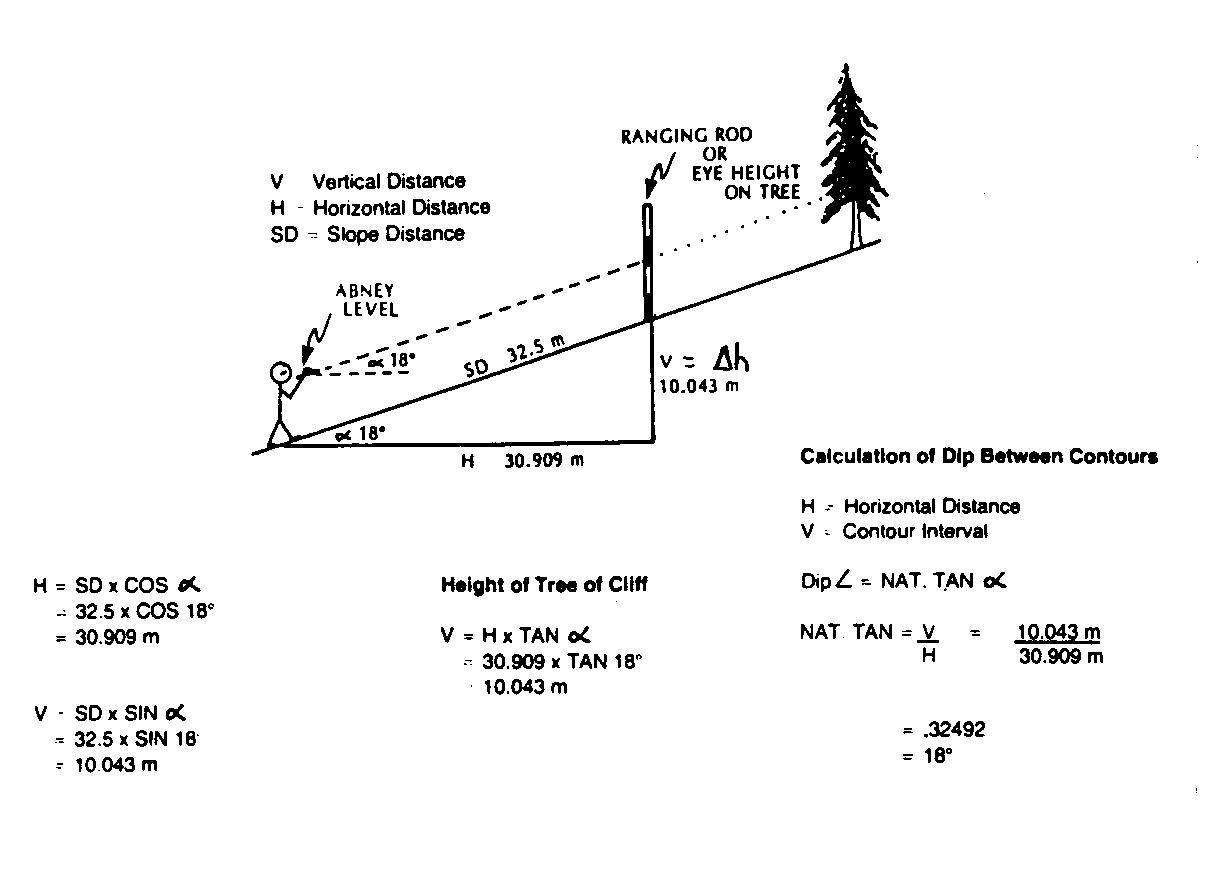

Abney Level


soil organic matter

Examination of data on North Wales soils shows that a good correlation exists between loss-on-ignition and organic C values, determined by Tinsley's method. Ignition for half an hour at 850° C, and for 16 hours at 375 ±5° C have both been employed. The latter has advantages over the former procedure. Regression lines and prediction limits for organic C from loss-on-ignition are given from the data obtained. Although these regressions are not necessarily expected to be generally applicable, examination of some published data suggests that closely similar expressions may be. The method, because of its simplicity, can be usefully applied in a wide range of survey, analytical and ecological studies, in spite of the known sources of error.
Two gravimetric procedures for determining carbon in soil, one a dry combustion method and the other a wet oxidation method, were compared with seven variants of the titrimetric method, all based on titrimetric determination of the dichromate consumed when soil is heated with dichromate and acid. The coefficients of variation of the methods were, as percentages: dry combustion, 0.76; wet combustion, 1.1; Tinsley I, 1.3; Tinsley II, 1.8; Tinsley III, 0.8; Anne, 1.3; Mebius, 1.8; Walkley and Black, 1.6 and Tyurin, 8.5. Taking the dry combustion method as standard, the percentage recovery of organic carbon from 22 soils was 99 for wet combustion, 95 for Tinsley I, 95 for Tinsley II, 97 for Tinsley III, 93 for Anne, 95 for Mebius, 77 for Walkley and Black and 93 for the Tyurin method. A variant of the Tinsley method (Tinsley III) is proposed as a quick procedure when the accuracy of dry combustion is not essential.


A simple ashing procedure for routine determination of soil organic matter is described. Two hundred fifteen soils from 19 states and Canada were ashed at 500° C and the percent weight loss plotted against the percent organic matter determined by Walkley‐Black titration. The resulting regression equation gave a correlation coefficient of 0.98. The organic matter content of experimental samples ranged from 0.64% to 52.4% as determined by the Walkley‐Black method. The proposed procedure incorporates a computerized weighing system and permits 1600 organic matter determinations per day.


SOIL ANALYSIS


ORGANIC MATTER
WALKLEY-BLACK METHOD


PRINCIPLE


1. In this reaction carbon is oxidized by the dichromate ion. Excess dichromate ion is then back titrated with ferrous ion.
a. Dichromate ion reacts with carbon as follows:
Cr2O72 3Co+ 16H+ 4Cr3+ + 3CO2 + 8H2O
b. Ferrous ion reacts with dichromate as follows:
6Fe2+ + Cr2O72 + 14H+ 2Cr3+ + 6Fe3+ + 7H2O


REAGENTS


1. Potassium Dichromate: K2Cr2O7


2. Ferrous Ammonium Sulfate: Fe(NH4)2(SO4)26H2O


3. Sulfuric Acid: H2SO4


4. Phosphoric Acid: H3PO4


5. Sodium Fluoride: NaF


6. Diphenylamine: C6H5NHC6H5
SOLUTIONS
1. 1N Potassium Dichromate: a. Weigh 49.04 g potassium dichromate (previously dried for 2 hours at 100 C) into a 1 liter volumetric flask. Dissolve and dilute to volume with deionized water and mix well.
2. 0.5N Ferrous Ammonium Sulfate
a. Slowly add 20 ml. sulfuric acid to a 1 liter volumetric flask containing 800 ml. deionized water.
b. Add 196.1 g ferrous ammonium sulfate. Dissolve, dilute to volume with deionized water, and mix well.
c. Prepare daily.


3. Diphenylamine Indicator:


a. Dissolve 0.500 g diphenylamine in 20 ml. deionized water.
b. Slowly add 100 ml. sulfuric acid. Carefully mix with a glass stirring rod. CAUTION: this solution is corrosive and can cause sever burns. Proper precautions are given on the MSDS sheet for sulfuric acid.


PROCEDURE


1. Weigh 1.00 g soil into a 500 ml. erlenmeyer flask.


2. Add 10 ml. of 1N potassium dichromate solution.


3. Add 20 ml. sulfuric acid and mix by gentle rotation for 1 minute, taking care to avoid throwing soil up onto the sides of the flask. Let stand for 30 minutes.


5. Dilute to 200 ml. with deionized water.


6. Add 10 ml. phosphoric acid, 0.2g ammonium fluoride, and 10 drops diphenylamine indicator.
7. Titrate with 0.5N ferrous ammonium sulfate solution until the color changes from dull green to a turbid blue. Add the titrating solution drop by drop until the end point is reached when the color shifts to a brilliant green.


8. Prepare and titrate a blank in the same manner.


9. Prepare one duplicate sample and one quality control sample with each set of samples analyzed.


CALCULATION


1. % Organic Matter = 10[1(S÷B)] X 0.67
S = sample titration
B = blank titration


QUALITY CONTROL


1. Values on the duplicate samples must agree within 20% of the average of the two values.
2. Values on the quality control sample must lie within the limits established for this sample.


NOTE
1. This procedure requires the routine use of sulfuric acid. Sulfuric acid is a corrosive, strong oxidant and should be handled with caution. Refer to the MSDS sheet for proper handling.


Saturday, December 15, 2012

TYPICAL RAIN 15 Disember 2012

TYPICAL RAIN INTENSITY
Dicember is North East Monsoon season normally drier month in Kedah. Rain normally spill over from east coast of Peninsular. Putrajaya is reported to be misty from one of  facebook  friend.It is probably changing rain front line abnormally move inland. Kedah may experience the same for the year.

 Today15 December 2012 two days before 2 days  gave accumulated rain 40mm. The day before that jus 1mm.
Today ,15
4.29 p.m :First half minute it drizzel than it increased in intensity for the next ten minute. Run off flow steadily increased.(high intensity rainfall lasted for 11 mins)
4.44 p.m : It changes to driszzel (lasted for 4minutes)
4.48 p.m : It increased to moderate intensity for 3 minutes
4..56 p.m :intensity change to moderate dirzzel
5.02 p.m : drizzel (3minutes)
5.15 p.m : run off still runing
5.35 p.m : no more run off


10 minutes high intensity rain gave runn off on  roadside


Run off


Run off with silt load


Rain Subsides and run off cease

Tank rises more than 6 inches due 40mm rain for half an hour
In a standar USLE run off plot would result at least 180litre
 run off considering some percentage of infliteration seepage.
Actual volume of water would have been 250 litres

All reserve tank refilled 

Dark cloud remain ,it givas drizzel  finally 12 hours period yield total 48mm rain. Run of zinc is 64 feet length  thus have to make some correction to standard length.


After the rain total rainfall was checked . Total amount for about  45 minutes amounting to 45 mm. Most probably 50% were result of first 10 minutes.Half an hour after the first rain new drizzel comes probably gave few millimeter more.By nightfall no more rain.


Rain probably continued throught the late night but not not aware  measurement seem to increased to total 48mm (4.29p.m-7.00am 15 Dec 2012). 16 Dec 2012 Morning however bright. It look evening to day will give some more rain.It really gives 45mm rain.The intensity pattern is the same. 17 Dec Morning Cloudy b
ut no rain in the evening and it brightens as day ends.
Half of it eveporated on the next sunny day and the other half on next day.

RAINFALL IN JANUARY (TIKAM BATU VILLAGE)
Wilting Point No No rain  for a week water reserve depleted
Earlier December saturated irrigation (2.5 liters) survive well in 10 days without irrigation  in present of rain


Saturated Bottle has 60% water(2.5 liters) lasted for 3 days 4 days deficit  permenent wilting point for lower leaves
Flood irrigation survive well and better than saturated irrigation for ten days with additional rain

Flood Irrigation much more deficit withoutrain compare to ten days with rain earlier


Flooding irrigation deficit after 3 days kill sahllow rooted young plant bigger  plant  minimally survived in January


Compare to flooding irrigation minor deficit after 10 days  with supplement rain in December


With Rain 10 day without watering survive well


January is Dry month for Kedah there is no rain from 13 Jan to 18 January 2013 untill 22th where there is 0.1mm rain. Heavier rain only came on 24th where the is 3 minute shower followed by 13minute drizell. Rain continues at midnight till morning. However total rain just 25 mm.Evepotranspiration for next two day everporated almost all the as eveporation is about 12mm per day unless the water is collected in resourvour or tank where surface eveporation is reduced due two smaller surface area.
BRUNEI RAINFALL
Brunei's climate is hot and humid. Average annual rainfall is about 2500mm along the coast and over 4000mm in the jungle-cloaked hills of the interior.Average annual rainfall is 2873.9 The wettest months are October, November and December, when average rainfall is over 300mm, while the driest are February and March, when average rainfall is about 130mm. November has the most rainy days, while February and March have the fewest.

Most of Agriculture Develepment area nearer the coast just average annual rainfall peobably around 3000mm however rain intensity is more important than average annual rainfall in factor that causes erosion.Thus using higher value will take into consideration of annomaly which causes flood in 20 Jan 2009 with 148.8 mm rain in 24 hour other major flood in 1962,1999(Temburong) and 2009(Muara and Tutong).

Rainfall factor in culculation of Erosion is R value :R=(9.28Pmm-8838.15)/100      joules/m2     : P (2873.9mm maximum 4000mm) is annual rainfall in mm. Therefor R for Brunei is = 178.3164 maximum will be 282.885

RAIN AND EROSION- USLE

A=RKLSCP

A    =    average annual soil loss in the project or farm area. 
                        R    =    rainfall erosivity index
                        K    =    soil erodibility factor
                        L    =    topographic factor, L for slope length
                        S    =    topographic factor, S for percent slope
                        C    =    a cropping-management factor
                        P    =    conservation practice factor


R=(9.28Pmm-8838.15)/100      joules/m2     : P is annual rainfall in mm

L=(l  meter/22.13 meter) 0.5

S   =     (65.4 sin2 θ + 45.56 sin θ + 0.065) where θ is the field slope in degrees


K=0.1317{2.1M to power 1.14 (1/1000)(12-OM)+3.25(S-2)+2.5(P-3)/100

K          =          0.1317[ 2.1M1.14(10-4)(12-OM) + 3.25(S – 2) + 2.5(P – 3)]/100

Where   K         is  the soil erodibility index (for the United States region)
M        is the product of (% silt + % very fine sand)(%silt + %very fine sand + %sand)
 or   (% silt + % very fine sand)(100-Clay)
OM     is the percent of organic matter
       is the soil structure value
       is the profile hydraulic permeability value  


S - SOIL STRUCTURE VALUE

S
        value
1 VFine Crumb < 1mm
1 V fine Granular <1mm
2 Fine Crumb<2
2  fine Granular <2
3 Medium Crumb <5
3  Medium Granular <5
3 V fine SAB/AB<5
3 FineSAB/AB<10
2 Medium SAB<20
2 Coarse SAB<50
2 Prismatic
2 Platy
2 Massive


          P - SOIL PERMEABILITY VALUE

      Pvalue
1     Rudua Excessively Drain
2     Tok Yong Well Drain
2     Cempaka Somewhat Imperfect
3     Lating Imperfect
4     Tepus Somewhat Imperfect
5     Poor
6     Binjai Very Poor

         M Field Test

                   M= (% silt + % very fine sand)(100-Clay)


Friday, December 14, 2012

SLOPE CALCULATION FROM SOIL MAP - ADA TUNGKU & BIRAU PENYELIDEKAN

TUNGKU

Instrument:

Ruler - mm, Measure linear the scale on the map . 750m is 71.5mm
Distance between two point is ratio of the scale


BIRAU PENYELIDEKAN
Linear Measurement is made on Computer Screen where 750m equal 110m
The map distances are measure on screen as well. Thus ration is base on screen measurement.


Red line 1,2,3,4 are the slopes to be measured


BIRAU PENYELIDEKAN SLOPE  MEASUREMENT
Slope measure map linear Distance no PERCENT 
No  mm scale mm=750m measure/linear meter contours tan degrees SLOPE
scale x hight=y x/y 100*x/y
u uX750m 4 kontour
1 8 110 0.072727273 54.54545 40 0.733333 36.25 73.33333
2 13 110 0.118181818 88.63636 60 0.676923 34.09 67.69231
3 6.5 110 0.059090909 44.31818 50 1.128205 48.45 112.8205
4 8 110 0.072727273 54.54545 50 0.916667 42.51 91.66667
5 20 110 0.181818182 136.3636 80 0.586667 30.4 58.66667
6 12 110 0.109090909 81.81818 30 0.366667 20.14 36.66667
7 19 110 0.172727273 129.5455 10 0.077193 4.41 7.719298

HYPOTHESIS: Extropolation OF SOIL TYPE & BOUNDRY FROM ASSOCATION MAP UNIT UNIT


White Sand using for Housing Site Probably Originate from Beach Sand unless it brough from outside. More like Spodic ridges thus road is built along this ridges to avoid waterlog.

On the site visit in December 2012
Auger Boring AEO profile
Spodic Material from soil pit


The above field checking on the spot proves the extrapolation is correct. The Soil is Rudua  (Haplothod) in Brunei is group as Epiquod


From Vegetation and landuse it is possible to extrapolate soil type and terrain


On Field Checked The  Association  mapped as Hapluhumult and Kandiudult  the steep hill found to be soil developed from sandstone over carbonecouse shale 

Sandstone derived soil overlying carbonecious shale


Sandy and silty material setteles quickly on field settlement checked

 Sandy and silts materials easily eroded when disturbed


TUNGKU ADA : Assocition Unit :Ultic Epiaquod-Hydraquentic Sulfaquept-Oxyaquic Haplohumult
Ultic Epiaquod - It is spodosol normally sandy more like old sandy beach ridges which saturated with water on the surface thus not high in elevation. Being ridges it pattern should be elongated.
Sulfaquept- is Inceptisoil not mature soil and Hydraquentic thus saturated with water so the lies in low lying waterlog basin or near the stream
Oxyaquic Haplohumult- Being Haplo thus deep soil (100cm-150cm) and soil is Ultisol thus matured but experience aquic moisture regime sometime thus has mottles in fluation zone normally very close to parent impermiable material . This soil lies in highly elevated area on slopes where  water flow. That somewhat hill area. Slope may be  15 to 20 degrees slope due to closess of contour line.

Site marked as Tunku 1 is not of sandy material but of shale derived soils on field check

Shale derived soil thus more clayey

More clayey better structured than previous sandstone derived soil


USING GOOGLE EARTH LOCATING SAMPLE POINT IN THE FIELD to determine drainage and other properties-Sampel Poin Tunku 1

PADNUNOK CLOSE UP
What Colour any Mottles?

LUAHAN ADA :Soil Association (1)Unit Oxyaquic Haplohumult-Typic Kandiudult  (2) Oxyaquic Haplohumult-Typic Epiaqualf
Oxyaquic-indicates soil that have mottling as result of somepart of the year soil is waterlog or saturated due to humid moisture regime  .Haplo indicate that the profile is deep more than 100cm  less than 150cm .Normally occur on slope thus subsoil water saturation above parent material. Typic Epiaqualf has aquic moisture regime thus water log. So more like occur in valley flat and near the river - reverine deposit. They are either T2  or T1. Thus this area is marked gray in hypothetical boundry.


TRACING SAMPLING SITE 1 & 2


SAMPLING SITE 1 - Determining exact spot & drainage


SAMPLING SITE 2 -Determining Drainage


LABU ESTATE TEMBURONG - Location & Vegetation


PADNUNOK SG BURONG!!!


PADNUNOK RAIN SHELTER CLOSE UP - To analyse Soil type


TUNGULIAN - Location ,Soil Map & Close up vegetation


EROSION IN THE NEIGBOURHOOD OF TUNGULIAN FOR ILLUSTRASIVE STUDY & EXPERIENCE