 |
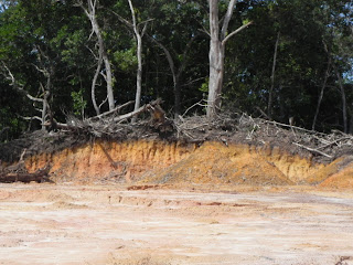
| White Sand using for Housing Site Probably Originate from Beach Sand unless it brough from outside. More like Spodic ridges thus road is built along this ridges to avoid waterlog. |
 |
| On the site visit in December 2012 |
 |
Auger Boring AEO profile
 |
| Spodic Material from soil pit |
 |
The above field checking on the spot proves the extrapolation is correct. The Soil is Rudua (Haplothod) in Brunei is group as Epiquod
 |
| From Vegetation and landuse it is possible to extrapolate soil type and terrain |
On Field Checked The Association mapped as Hapluhumult and Kandiudult the steep hill found to be soil developed from sandstone over carbonecouse shale
 |
| Sandstone derived soil overlying carbonecious shale |
 |
Sandy and silty material setteles quickly on field settlement checked
 |
Sandy and silts materials easily eroded when disturbed
TUNGKU ADA : Assocition Unit :Ultic Epiaquod-Hydraquentic Sulfaquept-Oxyaquic Haplohumult
Ultic Epiaquod - It is spodosol normally sandy more like old sandy beach ridges which saturated with water on the surface thus not high in elevation. Being ridges it pattern should be elongated.
Sulfaquept- is Inceptisoil not mature soil and Hydraquentic thus saturated with water so the lies in low lying waterlog basin or near the stream
Oxyaquic Haplohumult- Being Haplo thus deep soil (100cm-150cm) and soil is Ultisol thus matured but experience aquic moisture regime sometime thus has mottles in fluation zone normally very close to parent impermiable material . This soil lies in highly elevated area on slopes where water flow. That somewhat hill area. Slope may be 15 to 20 degrees slope due to closess of contour line.
Site marked as Tunku 1 is not of sandy material but of shale derived soils on field check
 |
| Shale derived soil thus more clayey |
 |
| More clayey better structured than previous sandstone derived soil |
 |
| USING GOOGLE EARTH LOCATING SAMPLE POINT IN THE FIELD to determine drainage and other properties-Sampel Poin Tunku 1 |
 |
| PADNUNOK CLOSE UP |
 |
| What Colour any Mottles? |
 |
LUAHAN ADA :Soil Association (1)Unit Oxyaquic Haplohumult-Typic Kandiudult (2) Oxyaquic Haplohumult-Typic Epiaqualf
Oxyaquic-indicates soil that have mottling as result of somepart of the year soil is waterlog or saturated due to humid moisture regime .Haplo indicate that the profile is deep more than 100cm less than 150cm .Normally occur on slope thus subsoil water saturation above parent material. Typic Epiaqualf has aquic moisture regime thus water log. So more like occur in valley flat and near the river - reverine deposit. They are either T2 or T1. Thus this area is marked gray in hypothetical boundry.
TRACING SAMPLING SITE 1 & 2
SAMPLING SITE 1 - Determining exact spot & drainage
SAMPLING SITE 2 -Determining Drainage
LABU ESTATE TEMBURONG - Location & Vegetation
PADNUNOK SG BURONG!!!
PADNUNOK RAIN SHELTER CLOSE UP - To analyse Soil type
TUNGULIAN - Location ,Soil Map & Close up vegetation
EROSION IN THE NEIGBOURHOOD OF TUNGULIAN FOR ILLUSTRASIVE STUDY & EXPERIENCE
|


No comments:
Post a Comment